How to enjoy the Little Belt Mountains in Montana
Introduction:
 |
| Belt Creek in the Sluice Boxes State Park |
The Little Belt Mountain Range is a northcentral Montana treasure, about the size of Glacier National Park at nearly 1 million acres, with peaks as high as 9,000 feet, limestone canyons, arches and spires, a blue-ribbon trout and floating stream, alpine lakes, most of the big game species, old ghost towns, the world famous-Yogo Sapphire, numerous campgrounds and picnic areas, backcountry and downhill skiing, a Wilderness Study Area, caves, a state wildlife game range, an experimental forest, six rental cabins, 15 formal campgrounds, numerous informal camping spots, and a designated Forest Service Scenic Byway in its middle.
Yet, despite multiple attractions this Island Mountain Range is overshadowed in the area by the Rocky Mountain Front, Bob Marshall wilderness complex and Glacier, and even the nearby Big Snowies Wilderness Study Area.
It is so large, 60-miles north to south, and 30-miles east to west, that it takes two Forest Service Ranger Districts with four offices to manage it: Belt Creek (between Monarch and Neihart)-White Sulphur Springs District , Judith (Stanford)-Musselshell (Harlowtown) District.
It appears to be a low-slung mountain range despite the size of some of its "peaks," because of its geology. It was created when igneous forces pushed up through a limestone crust, giving the high points a rounded appearance.
The range gives life to rivers like the Smith, Judith and Musselshell and Belt Creek.
Large elk herds, some of which winter on the Judith Game Range near Utica, make this a prime hunting area.
 |
| The McGee Coulee Arch |
The Scenic By-Way begins on U.S. 89 near Belt at Armington Junction and ends at White Sulphur Springs. Along the way tourists are introduced to the rich history of the range: the Sluice Boxes State Park, the old mining town of Monarch, the Sluice Boxes State Park, the historic Belt Creek Ranger Station, Showdown Ski Area, the Mizpah logging region and White Sulphur Springs with its healing Spa hot springs resort and the jumping off center for floating the Smith River.
The by-way gives access to many hiking trails and roads that will take you to them, such as the Sluice Boxes, Dry Creek, Hoover Creek trails, Pioneer Ridge, Crawford Creek, Memorial Falls, Jefferson Creek, Silvercrest Cross Country Ski and Snowshoe trails, Divide Road, O'Brien Creek, Ranch Creek and Deadman backcountry ski trails, Showdown (downhill) ski area, the Sheep Creek/Moose Creek area, and the list goes on.
To the east of the byway near Geyser is the Lonepine Road giving access to Wolf Butte, a glorious climbing destination and flanked by very climbable off-trail peaks, like Granite, the Taylor Hills, Anderson, Clendenin, and Mixes Baldy.
Further east, beginning at Utica or Hobson off U.S. 87/Montana 200 there's a great road along the Judith River, that cuts across to US 12. The road is a main access point for the Middle Fork of the Judith Wilderness Study Area, the Sapphire Village mining camp, the state game range, the Russell Point area where famed cowboy artist Charlie Russell worked before moving to Great Falls, and many limestone canyons.
Near Stanford, a good, gravel road parallels Dry Wolf Creek that ends at a campground at the base of Big Baldy Mountain, at 9,175 feet, the highest peak on the range. There is also access to trails and undesignated camp spots along this road, as well as a rentable Forest Service cabin.
In the Judith Gap area along Montana Highway 3 near Buffalo there's access to the "Sisters" with its tight limestone canyon.
From the west, just six miles from Great Falls, there's the road to Logging Creek Campground, and access to scenic trails along the way, like Pilgrim Creek, and the Deep Creek Figure 8 trail. This road eventually becomes the Divide Road that bisects the western half of the mountain range with access to Balsinger Creek, Taylor Hills, Tenderfoot Creek and upper Pilgrim Creek, coming out near Showdown.
Along U.S. 12 east of White Sulphur, the Forest Service has clearly marked numerous access points to hiking trails like the Daisy Dean Narrows, and Spring Creek.
 |
| Looking toward 9,125 feet Big Baldy Mountain, the Little Belts high point |
There's more than a lifetime of exploration in this range and beyond this author's ability and time to cover it all.
 |
| The Porphyry Lookout above Showdown Ski Area |
This book will attempt to share the best hikes in each of the ranger districts, some easy off-trail mountain climbs, and sites like the Sluice Boxes and Wolf Butte that lie outside the Forest Service jurisdiction.
Hiking off trail (grizzlies, wolves warnings)
Access points to Little Belts:
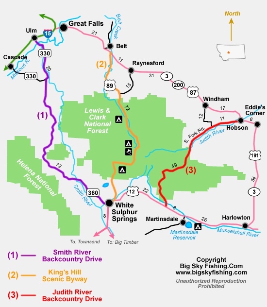
U.S. 89 Scenic By-way

(The following is from the Central Montana Tourism Office)
Passing through the Lewis and Clark National Forest and Little Belt Mountains, the Kings Hill Scenic Byway allows travelers to leisurely savor the rugged beauty and fresh air that are part of the Montana experience.
Stretching 71 miles along US Highway 89, the Byway winds its way along pristine mountain streams and is home to an abundant variety of wildlife. The gravel roads criss-crossing the main highway lead to 450 miles of spectacular mountain scenery, high country lakes, trailheads, campgrounds, and old mines.
Fishing, floating, mountain biking, horseback riding, downhill skiing and snowmobiling are just a few of the many activities available in this rugged country. There are 200 miles of marked snowmobile trails available from the Kings Hill area. Showdown Ski Area offers 34 downhill ski trails of varied terrain, rentals, lessons and a day use lodge. North of Kings Hill Pass, a Nordic ski area is available at Silver Crest with 17 miles of cross-country ski trails, one ungroomed and three groomed.
The Kings Hill Scenic Byway begins on US Highway 89 at its junction with US Highway 12. From the junction the Byway travels north through the Lewis and Clark National Forest to its junction with US Highway 87. Winter driving conditions can be difficult, check road conditions. Allow two hours time to leisurely drive this scenic route. Length of drive is 71 miles.
Interesting stops along the By-way:
- Armington Junction. The Montana Transportation Department rest stop has interpretive signs explaining the By-way and the junction itself
- Sluice Boxes Overlook. A high pull out where visitors can look down into the Sluice Boxes State Park's impressive limestone cliffs and emerald waters
- Monarch. A small mining community that has refurbished its historic railroad station that served the hard rock mines in the area and provided transportation for fishermen.
- Belt Creek Ranger Station. Historic ranger station with interpretive signs and a picnic area and access to the Crawford Creek and Pioneer Ridge trails
- Four Forest Service campgrounds. Aspen, Many Pines, Kings Hill, and Jumping Creek
- Neihart. Historic mining camp that now serves vacation homes and the ski area
- Memorial Falls. A popular short hiking destination a mile south of Neihart
- King's Hill Pass
at more than 7,400 feet offers access of a Forest Service Rental Cabin,
Showdown Ski Area, backcountry ski trails on either side of the
highway, and the Porphyry Peak Lookout Tower. You can drive to the
lookout, which is staffed during the summer. The lookout ranger will
give you a tour.
- Mizaph Overlook. A pullout about a mile south of Kings Hill Pass that has interpretive signs for an area that had been intensively logged and which has regrown. Very good views of the ski area
- White Sulphur Springs. Ranger district headquarters and home to a popular hot springs resort.
Divide Road:
South Fork of Judith River Road:
- Utica. Quaint little crossroads town that displays it historic store fronts and is home to the "Ox," a friendly bar with a formal name, "The Oxen Yoke," that serves giant hamburgers and enormous servings of French Fries.
- Sapphire Village. A strange, unincorporated collection of mobile homes, trailers and second homes that is held together by the general store/bar, "The Blue Nugget," named for the world-famous Yogo Sapphire gem that is mined nearby.
- Judith Station ranger station and nearby trailheads into the Middle Fork of the Judith Wilderness Study Area.
- Judith River Wildlife Management Area. A nearly 10,000 acres game range for elk and deer adjacent to the Middle Fork of the Judith Wilderness Study Area.
- Middle Fork of the Judith Wilderness Study Area. An 81,000 acres area under study for inclusion in the national Wildernes system.
- Russian Flats. A scenic, flat two-mile long grassland at about 6,200 feet with a campground and trailhead.
- The numerous campsites,
formal, such as the Forest Service's Indian Hill, Hay Canyon and Dry
Pole campsites, and the Fred M. Ellis campground that hug the tight
limestone canyon along the Judith River
Smith River Road
Also worth noting for access:
- U.S. 12
- U.S. 87/Montana 200
- U.S. 191
- Sheep Creek Road/Moose Creek Campground
- Lonetree Road access one mile east of Geyser
- Dry Fork of Wolf Creek access a mile west of Stanford
- Hike in Sluice Boxes State Park
- Drive the U.S. 89 Scenic By-Way between Armington Junction and White Sulphur Springs
- Float the Smith River
- Climb Big Baldy Peak and hike along its ridge
- Downhill Ski at Showdown Ski Area south of Neihart
- Cross Country Ski or Snowshoe at Silvercrest Area
- Visit Memorial Falls a mile south of Neihart
- Hike or backpack in the Middle Fork of the Judith Wilderness Study Area
- Visit one of the mountain range's mining ghost towns, like Barker-Hughesville or the Neihart Mining District
- Hunt for Yogo sapphires in the South Fork Judith
- Have a soak in the White Sulphur Springs
Tintina Mine at Black Butte on Sheep Creek Road could affect pristine Smith River
 |
| Tintina's Jerry Zieg explains the location of the Black Butte Mine north of White Sulphur in the Smith River headwaters |
Lots of variety to this day: I tried a new route on the Pioneer Ridge, did a formal tour of Tintina's proposed Black Butte copper mine at the head of the Smith River, and soaked at the Spa in White Sulphur Springs.
The highlight of the day was the tour of the proposed copper mine, a very controversial proposal because of its location.
Company officials appeared to be open to any question thrown at them.
Most of them involved in handling of tailings, the toxic waste rock left over after the copper is extracted.
 |
| On the mine site's large storage area, with Black Butte in the background |
 |
| Tintina's geologist Jerry Zieg taking questions from the public at a White Sulphur Springs mine presentation |
My natural inclination had been to support mining if it can be proven that the Smith is in no danger.
Those 200 well-paying jobs that would come from this development would benefit the locals and the state.
However, after visiting the site and hearing the company's side, I'd need much more assurance before supporting the mine.
Our state's legacy is too clear and present: mining has left lasting scars. The adjacent, mine-polluted Belt Creek drainage should be lesson enough.
We can't afford even the possibility of a polluted Smith.
Proposing a mine in the Smith's headwaters is inappropriate. This is sacred ground. There must be some places where development can't occur. This is one of those places.
Must do trails:
Memorial Falls, Trail No. 321. All seasons. Easy. (89)


SUMMARY: On designated trail with little elevation gain to first falls, about a half-mile round-trip. Add another quarter-mile and a small elevation gain to upper falls. EASY.
Sluice Boxes State Park walk-through (89/Logging Creek) Moderate

Yes, the teen-age party and cliff-jumping crowd may be clued in, but somehow those looking for a spectacular day hike in the area somehow forget about it.
The park is a narrow strip that covers awesome limestone canyons and emerald Belt Creek, 32 miles east and south of Great Falls on U.S. 89.
There are no designated hiking trails, but unofficial trails braid its canyon bottom and along its west slope.
The easiest way to get from one end at Riceville to where the bridge crosses Belt Creek on the Logging Creek Road, is to follow the former bed of a railroad track.
A narrow gauge railroad train used to ply this canyon from Great Falls to Neihart where ore cars would be loaded from the mines there and hauled back to Great Falls for smelting.
The 1953 flood tore out the trestles and by the early 1970s the canyon had pretty much been reclaimed by hikers and fishermen.
Those hiking the area see the remains of the old railroad; many ties are intact along the trail; there’s an impressive tunnel to walk through; concrete supports are still in place; and intricate rockwork shores up many crossings.
Around every corner there’s something interesting to see, from the limestone spires to the twisting creek, to an architecturally interesting double-topped limekiln at the mining ghost town of Albright. There are a number of intact buildings, ore cars and iron rail at Albright.
Depending on which route you hike through, there are between five and 16 crossings. Some of them can be quite deep.
On our trip Saturday the water was as high as I’ve seen it in the past dozen years. It went waist deep on several crossings.
I’d advise waiting a couple of weeks for the water to recede before doing this hike.
I wouldn’t discourage fishermen from hitting either the Riceville or Logging Creek Road bridge areas and wading up the creek from either of those ends.
There are two pretty good access points from the north: Riceville and about two miles up the Riceville Road from the bridge to a well-marked parking area. I like this higher-up starting point. It approaches Belt Creek from a limestone canyon from the east and is on a trail about 100 feet above the creek. At the beginning of the hike there is a little waterfall.
Approaching the park from the South means taking the long, gravel road from Stockett or taking U.S. 89 to the Logging Creek Road, which drops significantly to Belt Creek and is rutted and rocky and one-track in several spots.
To hike through, you’ll need to ferry a car to your end point, but well worth the effort.

Crawford Creek: (US 89) Trail 329 Easy


SUMMARY: An easy out and back hike for the first mile before climbing to the Belt Park Bench. Beyond a fenceline gate at the one mile mark, the trail switchbacks to the bench and can be hard to follow.


Pilgrim Creek Trail 304 (89-Logging Creek-Divide Road). Summer-Fall. Easy.

A quick Pilgrim Creek hike

 |
| Where Pilgrim Creek empties into Belt Creek |
This is one of the many Little Belt Mountain Range's gem hikes.


Big Baldy Peak (89-Dry Wolf Creek) Strenuous Numerous trail options
 Big Baldy Mountain (elevation: 9,175 feet) : Various routes (Pioneer Ridge, Snow Creek, Dry Wolf Campground, off main road).

Yogo Peak complex 'Stonehenge'
 |


Wednesday, July 19, 2023 trip:
I'm sure I've done Yogo Peak (elevation: 8,811 feet) in the Little Belts, but can't remember the circumstances.It may have been about seven years ago when I did a disastrous drive through from Kings Hill to Stanford on a road so bad I tipped my car into a tree, requiring some expensive body work. I sort of recall driving to Yogo base and scrambling up some talus. Not memorable.
This time though it was a different story.
I
figured I could reach the base of the peak by taking Forest Service
Road 3328, near the Winter Recreation Area turnout on US 89 up 4 miles
to its junction with Road 251, where I drove another 4 miles, stopped
and began hiking because of the rough road.
It was only another mile or so to the top of the peak.
It took about an hour to drive the 8 miles because the road is so full of rocks, talus and ruts.
But, instead of taking the road all the way I got off into the amazing boulders and talus of the less unnamed peaks to the south along the ridge line I had always assumed were Yogo Peak.
There are several "hole in the wall" formations, Easter Island and Stonehenge-type boulders, and other boulders that resembled huge monsters. In addition, there were many rocks balancing precariously atop others.
I spent considerable time scrambling around in these rocks before descending to the road for a short trip up to the top of Yogo. Yogo is nothing but a big pile of talus on a fairly flat ridge that ends with the concrete footings of what used to be Forest Service fire lookout.
The views along the ridge are breathtaking: I counted nine different mountain ranges I could identify, and there were at least a half-dozen more out there I couldn't figure out. I could see to the Bearpaws on the north near the Canadian border and the Absaroka range on the southern border of Montana. Nearby Big Baldy, the glaciated highest peak in the Little Belts at 9,177 feet, was a short distance away to the west.
My main goal in climbing Yogo was to get a clear overview of the north end of the Middle Fork of the Judith Wilderness Study Area and how the Prospect and Woodchopper ridges could be reached from it. It was interesting to see where the Yogo wildfire burned three years ago, but it touched only a small portion of this large area.
I'm surprised by the amount of opposition to this WSA that has been going on for nearly 50 years.
It is a shame that the Little Belts, roughly the size of Glacier Park, is without any designated wilderness despite places like the Middle Fork and Deep Creek-Tenderfoot, and even the Big Baldy area.
Unfortunately, motorcycles and quads have access with the road, that in many places forms the WSA boundary, and track into it, despite a ban on motorized vehicles.
One of the most enjoyable parts of the hike were all the wildflowers, particularly the bright blue larkspur and lupine.
 |
| Yogo Peak at the end of a very rough road |
 |
| Big Baldy across the Dry Wolf valley from atop Yogo Peak |
 |
| The boulder and talus pile in front of Yogo Peak |
Another look: Yogo Peak (89-Windham/Utica) Difficult because of its isolation/ Off Trail

Lake Elva below Yogo Peak. (Chris Englesman photo from Outbound Collective)
From an August 2018 hike: SUMMARY:
Yogo Peak is an easy scramble up crude roads on the west side of the
peak, reachable from the road that begins at Kings Hill Pass and goes to
Dry Wolf Creek/Stanford. Reaching those roads is difficult unless you
have a high clearance vehicle. Yogo
Peak, at an elevation of 8,801 feet, is one of the giant peaks in the
center of the Little Belt Mountains. On the skyline looking east from
the Showdown Ski Area it is the high peak just south of Big Baldy.If you have a 4-wheeler or even a motorcycle it is easily accessible.Hiking up the mountain requires some planning. There are also some cautions about what you might drive to a trailhead.Forest
Service Road No. 251 begins at Kings Hill Pass and it is possible to
take it across the high mountain divide to Dry Wolf Creek Road. It is the best way to approach the mountain. The road
can be pretty rough to Teepee Butte, and nearly impossible for most
highway vehicles, including small SUVs from there.Anyway,
Road 251 takes a right turn at Teepee Butte and to the talus base of the mountain. If the road is too rough beyond
Teepee Butte, park it and walk up the road where the climb to the top is
obvious.At this point I would not recommend this road to anyone.Rather
than using Kings Hill as a starting point, the drive can be shortened
by turning off U.S. 89 near the Silvercrest Cross Country Ski Area at
the so-called "Cemetery" turn marked by a white fenced gravesite on
Forest Service Road 3328 towards Slide Rock. It eventually hooks up to
Road 251.Of
note is an alpine lake on the east flank of the peak. I've only seen
it from above, but note that there appears to be a steep trail down to
it from a rough road about 1.5 miles east of the peak on 251. This road
is marked on the Forest Service map as 251-B. My SUV slid off this
road into a tree, pushing in the passenger side door. Be forewarned! 
 |
| Lake Elva below Yogo Peak. (Chris Englesman photo from Outbound Collective) |
From an August 2018 hike:

Pioneer Ridge Loop (89) Difficult/Off Trail


Pioneer Ridge loop Trail No. 333 4.7 miles. Starts and ends just north and east of the Belt Creek Ranger Station off U.S. 89. Park at the ranger station and walk the tenth of a mile to the trailhead. This is a trail that can be used to climb Big Baldy Peak, a distance of 10 miles, and at least 4,000 feet in elevation gain. This is a great hike, in and of itself. However, this loop trail is a great, scenic if steep workout not far from Great Falls. Take the trail some 2 miles to a ridgeline just under 7,000 feet. It snakes in and out of forest and open, grassy, wildflower-filled slopes. At the ridge, the trail bends to the south. Go the opposite direction, following the rock ridge outcroppings to the north. There's an abandoned Forest Service trail that is fairly easy to follow that rises to a rocky, granitic summit, the high point. Then it descends on the ridge line, ultimately breaking out into an open elk meadow. Stay on the light trail and ridge, eventually descending nearly 2,000 feet to the creek bottom. From the openings, there are good views of Big Baldy, Neihart and Long Peaks to the south, the Showdown Ski Area.

Buffalo Canyon/Twin Sisters (Buffalo access/Hobson) Difficult/Off Trail
 |
| Wayne Phillips enters the Buffalo Canyon |
 |
| The canyon gave us the finger |
 |
| H.Wayne Phillips demonstrates how narrow Dark Canyon is |
 |
| We felt a little safer helping Nora Gray with a piece of rope |
When you do a hike like this you realize how large this isolated Island Range mountain range is. Actually, the range itself, about 1 million acres is the size of Glacier Park. So, we're talking big here.
Hobson is about 80 miles east of Great Falls.
This is not a heavily used part of the Little Belts because access is on gravel away from population centers.
We started at day break and came out at dusk, having covered 11.3 miles and gained and lost over 3,000 feet.
Buffalo Canyon is a spectacular complex of limestone gulches, intersected by other gulches. After a short walk through Buffalo Canyon, we detoured up the Dark Canyon to reach the top of a ridge line that took us to the Twin Sisters (elevations: 7,489, 7,496 feet), actually exposed bumps on the ridge line.
The canyons are every bit as spectacular as the limestone canyons and spires of the Gates of the Mountains Wilderness Area between Great Falls and Helena.
To get to the ridge we had to use a piece of rope to do one small pitch, although it probably wasn't necessary to rope up.
While much of the day was off-trail, we did a loop by staying on the ridge after climbing the peaks and using Forest Service trails and ATV roads to get back.
Because this area is so remote (it took us 2.5 hours to drive to the trail head from Great Falls), it gets very little use.
The gravel road is not too bad, although I'd recommend a high clearance vehicle, and there are two heavy gates to open and close.
We drank in the beauty of the surrounding mountain ranges on the ridge walk. On a clear day it would be possible to see the entire state North to South from the high points. We could see the Absaroka Range to the south, and haze blocked clear views of the Beartooths.
To the northwest, there is the Highwoods, to the northeast, the Moccasins and Judiths, to the southeast, the Big and Little Snowies, and to the southwest, the Castles and Crazy ranges.
In retrospect, I wish we had stayed low rather than gone high and climbed the peaks.
Unfortunately, the foliage in this area wasn't spectacular and not lit up in fall colors like the rest of the Little Belts. The Mountain Maple, in bright yellow, offered the best color
The canyon is simply fascinating and would offer hours of exploration.

Rickards Canyon (Middle Fork Judith WSA)(Windham/Utica) Moderate/Off Trail

On a Wayne's Wednesday hike combined with a Montana Wilderness Association exploratory we took a look at Rickard Canyon that is part of the Middle Fork Judith Wilderness Study Area.
This area is north and isolated from the star attraction of the Middle Fork, the river itself. It is accessed from the road that cuts through the Judith Game Range and runs past the range headquarters.
We were told to expect to walk on a road part way and with this dusty and smoky season that prospect wasn't too enticing.
What we got was a walk up a couple of limestone canyons reminiscent of the Gates of the Mountains Wilderness with meadows filled with lush, (still) green high grass. The air quality even cooperated, opening to bright if somewhat hazy skies. At least it was somewhat clear while we were there.
What was supposedly a road receded within two miles to a nice hiking trail that's not on the map, but what has been maintained probably by outfitters.
Pressed by time constraints we didn't follow the trail to its conclusion, a trail that was pointed straight at Kelly Mountain. I figured we were about 1.5 miles below the peak where there is a trail that travels across the Woodchopper Ridge to the south and Kelly and Yogo peaks to the north.
While we assumed that this area might be dropped from the WSA boundaries, we came away convinced that this is a worthy part of the study area, and would support a primitive use designation if outright wilderness is not approved.
As you drive through the South Fork area you realize there are dozens of these canyons in the Judith part of the Little Belts.
The battle for the Middle Fork Judith has been going on for more than 50 years.
The Rickard area should remain as it is.
Bandbox Peak (Dry Wolf Creek) Strenuous/Difficult/Off Trail

Summary: DIFFICULT/OFF TRAIL. Bandbox is climbed by ascending one of a number of ridges right up from the Dry Wolf campground or a mile or two beyond the campground up the road. It is about 2,000 feet up the mountain from the valley floor.
We had used this area in the past as a jumping off point to ski up the massive Big Baldy Mountain (over 9,000 feet) in the spring. While we were doing that we looked east and south and spotted the big, above-timberline Bandbox and vowed to return.
Bandbox is easily climbed by ascending one of a number of ridges right up from the campground or a mile or two beyond the campground up the road. It is about 2,000 feet up the mountain from the valley floor.
The views of Big Baldy and Yogo peaks get progressively better as you ascend to the ridgeline. It is a true walk up where you don’t have to use your hands. The way is marked by giant rock cairns.
On top you can see Gibson Peak to the north, Butcherknife and Baldy to the west, Yogo and the parallel Ettien and Sand Point ridges to the south, to the east many rugged limestone canyons.
We left Great Falls before 7 a.m., were on the trail before 9 a.m., and on top before 11 a.m., and back to the car before 1 p.m., and home around 2:30 p.m.
It was surprising to see how green it was up this canyon. Far cry from the previous years of drought we’ve suffered through the past two decades.
We noted the Forest Service Cabin on Dry Wolf and decided we’d be back in several months to rent it to pursue the various trips we had conceptualized.
Hoover Creek (89) Moderate Trail 732 Easy/Moderate

SUMMARY: You'll get our feet wet on this hike no matter how you do it or which trail you travel.
Neihart Baldy (from town of Neihart) (89/Carpenter) Difficult/Strenuous Off Trail

On top Neihart Baldy
 |
| On top Neihart Baldy |
McGee Coulee Arch (off Dry Fork) Difficult/Off Trail. Starts on former Road 3311
 | ||
| Wayne Phillips underneath the arch on steep scree slope |
 |
| Katie got up above us |
Wayne agreed to take Katie and me there Saturday, and I was just blown away by this spectacular off-trail feature hidden in the limestone cliffs.
To reach it we hiked 1.75 miles to some livestock watering tanks and turned up a ridge above a deep gulch, which was flanked on the other side by the cliffs. We found a nice game trail that took us up another quarter-mile to another draw where we walked across the gulch and then side-hilled up to this large arch.
Wayne had discovered it accidentally, and approached it differently, coming steeply up from the bottom through the arch. We found a game trail above the arch. We were able to climb into the cliffs and look at the arch below us. We had come 2.25 miles and gained a little more than 800 feet.
After a scenic lunch on a flat bench in the cliffs we were able to walk cross country on good elk trails, eventually descending to McGee Coulee, having completed a loop.
Because the arch is tucked back in a gulch without a trail, I'm amazed that Wayne was able to discover it.
Walking back down to McGee Coulee we had great views of Otter Mountain (elevation: 6,683 feet), which is at the end of a long ridge above the coulee. We could have easily climbed it, but because of fire smoke and the heat of the day, decided that would be for another time.
From Nov. 25, 2020 trip that included a climb of Otter Peak:
The skies cleared and we headed for the Little Belts to climb Otter Peak (elevation: 6,713 feet) after walking under the McGee Coulee Arch.
We had done the Arch in September and had seen Otter in the close distance up McGee Coulee. It seemed a shame not to climb that close at hand. And, that's why we returned Tuesday.
We took the west ridge up toward McGee Coulee, although Mark Hertenstein thought it might have been better, and with less deadfall to climb over, had we taken the east slope.
Last time we did the arch we approached it from above. This time we hit it from the bottom, climbing straight up through a large scree field.
This proved to be a much better way to go.
After a walk along the flanks of the Sawmill Ridge, we dropped back down through snow to McGee Coulee at the foot of Otter Peak. From this point it is about 1,200 feet up a relatively steep, and sometimes open slope.
On top we found that there had been a recent herd of elk there that had churned up the hard-pack snow, and the elk had left their calling-card droppings everywhere.
The views from the top were quite good ----- Mount Barker, immediately to the east was the highest point, although we could see Long and Neihart Baldy peaks, Servoss, Big Horn and Thunder mountains, and then out onto the Great Plains toward the buttes near the Rocky Mountain Front, the Bearspaws, and Snowies.
The sky was a deep blue, highlighted by a bright sun, that despite a relentless wind, kept us relatively warm.
We walked 7.2 miles and gained more than 2,200 feet, driving only 45 miles from Great Falls.


Tillinghast (89/Belt Park) Trail 322 Moderate

Katie above Tillinghast Creek at flood level
 SUMMARY: Moderate and pleasant hike to a remote creek bottom.
From May 24, 2020 trip:This time it was a 45 minute drive to the Belt Park Road south of Monarch and to a great trailhead not even a mile to the west.
On
Thursday Wayne and I did a long loop that went from the trailhead to
the junction with the Thunder Mountain trail and after a short lunch,
straight up Monarch Mountain and then along that mountain's ridgeline
before dropping back to the trail not far from our starting point.
The
drop to the Thunder Mountain junction was just under 800 feet over
about 3.1 miles. We gained 1,000 feet in .7 miles straight up to a
saddle on the Monument Mountain ridgeline.
On
Saturday, Katie and I went from the trailhead along the trail to a
point where we could drop straight down to the creek, where we had lunch
and turned around. We covered 4 miles roundtrip and gained and lost
about 1,100 feet.
The
scenery is dominated by towering Ponderosa pine trees and juniper
bushes. There's tons of deadfall littering the forest floor. These are
Ponderosas like you'd find in the Lincoln area, very surprising for a
forest I'm used to seeing in lodgepole.
Tillinghast Creek is raging, and we did not attempt a crossing.
I'll
do that later in the season when the snowmelt is gone and we can hike
that Thunder Mountain trail, perhaps climbing Big Horn and Thunder
mountains, the big boys in this area.
We had great views of those mountains much of the trip or whenever the trees opened up.
We
were treated to some nice open, grassy areas, particularly the the
bench not far from the Thunder Mountain Trail. At the junction the
high Belt Creek cliffs, much like those seen in Sluice Boxes State Park,
are visible on the flank of Monarch Mountain.
On top, there were terrific views of Big Baldy, Long and Niehart Baldy peaks. Belt Park was a massive, green oasis.
Tillinghast Creek was far below the trail and we caught only glimpses until we dropped to the bottom.
We
were treated to a variety of alpine flowers, particularly Lady Slipper
(Calypso) orchids, Shooting Stars, Bluebells, Holly Grape, and Fairy
Belles. On the hike up the side of Monarch Mountain I spied and
photographed a chocolate lily, quite a find and visual treat.
Now that access has become so easy I plan to return regularly and might even try it in the winter on backcountry skis!
Paine Gulch (89) Trail 737 Moderate

Dry Gulch Ridge above Paine Gulch
 |
| Katie above Tillinghast Creek at flood level |

On Thursday Wayne and I did a long loop that went from the trailhead to the junction with the Thunder Mountain trail and after a short lunch, straight up Monarch Mountain and then along that mountain's ridgeline before dropping back to the trail not far from our starting point.
The drop to the Thunder Mountain junction was just under 800 feet over about 3.1 miles. We gained 1,000 feet in .7 miles straight up to a saddle on the Monument Mountain ridgeline.
On Saturday, Katie and I went from the trailhead along the trail to a point where we could drop straight down to the creek, where we had lunch and turned around. We covered 4 miles roundtrip and gained and lost about 1,100 feet.
The scenery is dominated by towering Ponderosa pine trees and juniper bushes. There's tons of deadfall littering the forest floor. These are Ponderosas like you'd find in the Lincoln area, very surprising for a forest I'm used to seeing in lodgepole.
Tillinghast Creek is raging, and we did not attempt a crossing.
I'll do that later in the season when the snowmelt is gone and we can hike that Thunder Mountain trail, perhaps climbing Big Horn and Thunder mountains, the big boys in this area.
We had great views of those mountains much of the trip or whenever the trees opened up.
We were treated to some nice open, grassy areas, particularly the the bench not far from the Thunder Mountain Trail. At the junction the high Belt Creek cliffs, much like those seen in Sluice Boxes State Park, are visible on the flank of Monarch Mountain.
On top, there were terrific views of Big Baldy, Long and Niehart Baldy peaks. Belt Park was a massive, green oasis.
Tillinghast Creek was far below the trail and we caught only glimpses until we dropped to the bottom.
We were treated to a variety of alpine flowers, particularly Lady Slipper (Calypso) orchids, Shooting Stars, Bluebells, Holly Grape, and Fairy Belles. On the hike up the side of Monarch Mountain I spied and photographed a chocolate lily, quite a find and visual treat.
Now that access has become so easy I plan to return regularly and might even try it in the winter on backcountry skis!
 |
| Dry Gulch Ridge above Paine Gulch |
My wife and I took a lovely snowshoe up this gulch covering a little more than two miles and gaining about 550 in elevation beneath some towering spires on this Little Belts Mountain hike.
The gulch is pretty hidden because a private inholding sits at its trailhead for Trail No. 737.
This was owned by the late geologist David Baker, a real character, and and expert and promoter of the Little Belts.
The Forest Service has established a trailhead to the south of his gated and posted property. There's a brown Forest Service "TH" sign visible from U.S. 89.
The gulch is located just a little north of where the old Lazy Doe bar and restaurant was located. Unfortunately, this landmark and eatery was torn down last year and it looks as though the place never existed.
There is a good public parking spot for your hike a couple of hundred yards north and west of the trailhead where there's a state historical sign on one of the Minuteman III intercontinental ballistic missiles located in the area.
The trail skirts Baker's place and then climbs steadily above the tiny rivulet at the bottom of the gulch. In about a mile the first of the large outcrops appear, an impressive sight. There are also several side gulches to the north.
There are lots of downed trees and if you're cross country skiing be forewarned of steep, tight terrain where turns could be terrifying if there's ice. A skier had been there ahead of us and before the most recent storm and left his faint tracks. I'd recommend skins for up and down some of the tight spots.
We were on snowshoes and didn't have any trouble, except for one large tree across the path.
The forest is a combination of lodgepole, Doug Fir and Ponderosa pine.
At about 1.5 miles the trail breaks out in a flat, open area beneath the Dry Fork Ridge to the north and the back of Sun Mountain to the south.
Here the hillsides have been scorched in a summer wildfire and there are only small stands of live pines, juniper and aspens, but the scenery is positively thrilling.
The trail goes for another mile and a half or so.
This valley would be the perfect spot for climbing Sun or Servoss mountains or the Dry Fork Ridge.
Deep Creek Figure Eight/(Logging Creek area) Strenuous
Trailhead: Forest Road 839
Trail Ends: Mill Creek Saddle Trail Junction 308
The start of the trail in Mill Creek is the start of the Deep Creek Figure 8 Loop National Recreation Trail. Deep Creek Trail (303) can be used to access the Smith River and for fishing in the North Fork of Deep Creek. Use of the upper 6.1 miles by horses and motorized vehicles is heavy. The lower 2.7 miles is in the bottom of the creek and not maintained. The lower portion is very rough. Open to motorcycles.
Area Map: Lewis and Clark (Jefferson Division)
Balsinger Creek (Divide Road) Strenuous Trails 343/344
 |
| Several of the nice outcrops |
SUMMARY: A steep out-and-back hike to the Tenderfoot off the Divide Road. The
Balsinger hike differs from the Taylor Hills hike in that it gets to
the Tenderfoot by staying more in the trees and the Taylor Hills hike is
more open and passes through a working ranch. I’ve seen elk herds on
the Taylor Hills hike. From trip Aug. 14, 2008: (Note: there was a major summer-long wildfire in this area in 2021)
Here’s a rule of thumb for any hikes off Divide Road in the Little Belts --- it’s going to be steep.
I’ve done the Pilgrim Creek hike and the Taylor Hills hike to the Tenderfoot from that road in years past.
On Wednesday I went to explore the Balsinger Creek hike into the Tenderfoot.
It far exceeded my expectations for a nice day hike.
And it followed the Divide Road Rule by dropping nearly 2,000 feet, which meant having to climb back out at the end of the hike.
All
these hikes are from well-marked trailhead. It’s just a long drive to
get to them. I drove to just below Kings Hill Pass and headed west to
reach Balsinger Creek trailhead and came home by way of Logging Creek
and Stockett. From Balsinger Creek it took me an hour and a half to get
home, although it is only about 50 miles away. The road is good, it’s
just that it is gravel and winding.
The
Tenderfoot Creek drainage is a main tributary for the wild Smith River.
Likewise, Balsinger Creek is a main tributary of Tenderfoot Creek.
The
Tenderfoot is a special, wild place and in the past has been proposed
for wilderness designation. I can see why. The isolation, scenery and
fishing are outstanding.
While
the trail signs say it is about 4 miles from Divide Road down to
Tenderfoot Creek by way of Balsinger, I’d add another mile, at least.
The
first three or so miles of the trail are very good and well marked. The
last mile and a half, where the Taylor Hills cutoff trail comes in is
quite sketchy. I counted more than 20 crossings of the creek in this
final stretch. All-told there are 30 crossings from the top down to
Tenderfoot. Multiply that times two for the trip.
The
top part of the trip is open, offering good scenic views of the
southwest part of the Little Belts. Then it descends into pleasant
lodgepole forest.
The
final mile is a narrow canyon and the creek rushes through it into deep
fishing holes, tumbling in many spots into waterfalls.
I saw lots of fish darting around in the water and feeding on a plentiful moth hatch.
The
canyon stretch reminded me a lot of Pilgrim Creek, another wilderness
candidate in the Little Belts. Both Balsinger and Pilgrim have large,
flat rock bottoms and are similar in looks to an Appalachian stream.
I wish I had brought my fishing hole.
The
Balsinger hike differs from the Taylor Hills hike in that it gets to
the Tenderfoot by staying more in the trees and the Taylor Hills hike is
more open and passes through a working ranch. I’ve seen elk herds on
the Taylor Hills hike.
Both
trails appear to get most of their use from mountain bikers rather than
hikers. In the fall it’s probably hunters on horseback.
Despite its steep nature, I’d encourage anyone to check out this wild country hike.
I’ve done the Pilgrim Creek hike and the Taylor Hills hike to the Tenderfoot from that road in years past.
On Wednesday I went to explore the Balsinger Creek hike into the Tenderfoot.
It far exceeded my expectations for a nice day hike.
And it followed the Divide Road Rule by dropping nearly 2,000 feet, which meant having to climb back out at the end of the hike.
All these hikes are from well-marked trailhead. It’s just a long drive to get to them. I drove to just below Kings Hill Pass and headed west to reach Balsinger Creek trailhead and came home by way of Logging Creek and Stockett. From Balsinger Creek it took me an hour and a half to get home, although it is only about 50 miles away. The road is good, it’s just that it is gravel and winding.
The Tenderfoot Creek drainage is a main tributary for the wild Smith River. Likewise, Balsinger Creek is a main tributary of Tenderfoot Creek.
The Tenderfoot is a special, wild place and in the past has been proposed for wilderness designation. I can see why. The isolation, scenery and fishing are outstanding.
While the trail signs say it is about 4 miles from Divide Road down to Tenderfoot Creek by way of Balsinger, I’d add another mile, at least.
The first three or so miles of the trail are very good and well marked. The last mile and a half, where the Taylor Hills cutoff trail comes in is quite sketchy. I counted more than 20 crossings of the creek in this final stretch. All-told there are 30 crossings from the top down to Tenderfoot. Multiply that times two for the trip.
The top part of the trip is open, offering good scenic views of the southwest part of the Little Belts. Then it descends into pleasant lodgepole forest.
The final mile is a narrow canyon and the creek rushes through it into deep fishing holes, tumbling in many spots into waterfalls.
I saw lots of fish darting around in the water and feeding on a plentiful moth hatch.
The canyon stretch reminded me a lot of Pilgrim Creek, another wilderness candidate in the Little Belts. Both Balsinger and Pilgrim have large, flat rock bottoms and are similar in looks to an Appalachian stream.
I wish I had brought my fishing hole.
The Balsinger hike differs from the Taylor Hills hike in that it gets to the Tenderfoot by staying more in the trees and the Taylor Hills hike is more open and passes through a working ranch. I’ve seen elk herds on the Taylor Hills hike.
Both trails appear to get most of their use from mountain bikers rather than hikers. In the fall it’s probably hunters on horseback.
Despite its steep nature, I’d encourage anyone to check out this wild country hike.
Tenderfoot Creek/ Reynolds-Wood mountains climbing options (Sheep Creek Road) Trail 342 Strenuous
 |
| One of the many, tough Tenderfoot crossings |
 |
| Nearing the top of Mount Wood |
SUMMARY:
A difficult off-trail climb of two remote, but scenic southwest Little
Belt mountains, via Sheep Creek/Moose Creek roads.
From trip June 19, 2006:We
really weren’t looking for a tough workout when we set out to climb a
couple of remote mountains (Wood, elevation: 7,525 feet) and Reynolds
(7,175 feet) south of Tenderfoot Creek Saturday, but we got that workout
nonetheless.
We
were foolish enough to think these Little Belt peaks were easily gotten
from this wild creek on the west side of the range. So, we didn’t carry
topo maps, but relied on the rough Jefferson Division map from the
Lewis and Clark National Forest.
This
area has been discussed off and on as a wilderness candidate. The creek
is a main feeder stream into Smith River. The access is tricky and
tough any way you approach it. I’ve usually come into the Tenderfoot by
way of the Taylor Hills Trail off Divide Road not far from Pilgrim
Mountain. Last year I discovered it was more than a 2,000 foot drop into
the creek with the attendant 2,000 foot return in very steep country.
This
is ranching country and there’s been some mining here. In spots the
ATVers and motorcyclists “own” it. Fishing is great from top to bottom.
So’s the hunting if you can get permission to enter this land to
retrieve your elk. If you’re lucky enough not to encounter one of the
motorheads you will have as wild an experience as you can get.
That’s what we had last weekend.
We
entered this country by way of the Sheep Creek Road south of Kings Hill
Pass and at Eagle Park picked up a single track to a gate at Reynolds
Park, where Camas was in full bloom in the wetlands. We easily found the
public land along Urvi Creek, skirted the private land and found a
great game trail that dropped us steeply (600 feet) into Tenderfoot
Creek where Balsinger Creek comes in.
We
knew that the main Tenderfoot Creek Trail No. 342 was across the creek.
I thought we had it made if we could get across the creek to that trail
because I hadn’t carefully studied the map, which shows multiple creek
crossings along our route.

Lots of debris on this trail, like this dead motorcycle
Because
of the abundant rain the creek was swollen. We stripped off our boots
and put on sandals and clogs for the frozen wade. The force of the
rushing water made the crossing somewhat treacherous. We steadied
ourselves with our hiking sticks.
I still tingle when I think of that first crossing.
To
make a long story short we found ourselves crossing the creek 10 times
between Balsinger and just beyond the Taylor Hills trail junction (about
3 miles) where we began our climb. I gave up on the clogs and left on
my leather boots because their support lent some safety to our task.
This was exhilarating.
The
Tenderfoot winds its way through a steep volcanic canyon here. It is
also heavily forested. The scenery as well as the cold creek was
breathtaking.
The trail hasn’t been cleared in some time and it added to the wild nature of this hike.
While we enjoyed this experience, it wasn’t what we had come for --- we were after a couple of high mountains.
The
crossings took the spring out of steps and gobbled lots of time. We
made less than a mile an hour along this stretch of Tenderfoot. Along
the way we passed some unexplainable heavy mining equipment on the
trail, an old miners shack and a dead motorcycle, testament to this
area’s ruggedness.
About
a half mile beyond the Taylor Hills junction we recrossed the
Tenderfoot and head up the flank of Wood peak, some 2,500 feet above us.
We traveled through a forest of pencil-thin and densely spaced
lodgepoles with lots of tree debris at foot.
We found our ridgeline and two hours later were atop the tree-covered Woods anticipating Reynolds.
Reynolds is a long, narrow pile of volcanic talus.
Getting
off Reynolds and back to our car would be tricky because most
ridgelines dump you back down into the Tenderfoot. We knew we had to
stay on the ridgeline back to the one-track road or sidehill across
Reynolds to reach it.
After
a small false start down toward the Tenderfoot we found a good packers
trail that eventually led us through a large clearcut and then down to
Reynolds Park.
When the trees cleared we could see this magnificent country clearly on this bright day.
There were the Crazy, Castle, Big Belt (Edith and Baldy peaks), Bridgers, Gallatins, and Absaroka ranges on the horizon.
We figured we had gained more than 4,000 feet going up and down ridgelines, a respectable day for any mountain range.
We
had also gained a deep respect for this Tenderfoot country, more
convinced than ever that its wild character merits wilderness
protection.
We were foolish enough to think these Little Belt peaks were easily gotten from this wild creek on the west side of the range. So, we didn’t carry topo maps, but relied on the rough Jefferson Division map from the Lewis and Clark National Forest.
This area has been discussed off and on as a wilderness candidate. The creek is a main feeder stream into Smith River. The access is tricky and tough any way you approach it. I’ve usually come into the Tenderfoot by way of the Taylor Hills Trail off Divide Road not far from Pilgrim Mountain. Last year I discovered it was more than a 2,000 foot drop into the creek with the attendant 2,000 foot return in very steep country.
This is ranching country and there’s been some mining here. In spots the ATVers and motorcyclists “own” it. Fishing is great from top to bottom. So’s the hunting if you can get permission to enter this land to retrieve your elk. If you’re lucky enough not to encounter one of the motorheads you will have as wild an experience as you can get.
That’s what we had last weekend.
We entered this country by way of the Sheep Creek Road south of Kings Hill Pass and at Eagle Park picked up a single track to a gate at Reynolds Park, where Camas was in full bloom in the wetlands. We easily found the public land along Urvi Creek, skirted the private land and found a great game trail that dropped us steeply (600 feet) into Tenderfoot Creek where Balsinger Creek comes in.
We knew that the main Tenderfoot Creek Trail No. 342 was across the creek. I thought we had it made if we could get across the creek to that trail because I hadn’t carefully studied the map, which shows multiple creek crossings along our route.
 |
| Lots of debris on this trail, like this dead motorcycle |
I still tingle when I think of that first crossing.
To make a long story short we found ourselves crossing the creek 10 times between Balsinger and just beyond the Taylor Hills trail junction (about 3 miles) where we began our climb. I gave up on the clogs and left on my leather boots because their support lent some safety to our task.
This was exhilarating.
The Tenderfoot winds its way through a steep volcanic canyon here. It is also heavily forested. The scenery as well as the cold creek was breathtaking.
The trail hasn’t been cleared in some time and it added to the wild nature of this hike.
While we enjoyed this experience, it wasn’t what we had come for --- we were after a couple of high mountains.
The crossings took the spring out of steps and gobbled lots of time. We made less than a mile an hour along this stretch of Tenderfoot. Along the way we passed some unexplainable heavy mining equipment on the trail, an old miners shack and a dead motorcycle, testament to this area’s ruggedness.
About a half mile beyond the Taylor Hills junction we recrossed the Tenderfoot and head up the flank of Wood peak, some 2,500 feet above us. We traveled through a forest of pencil-thin and densely spaced lodgepoles with lots of tree debris at foot.
We found our ridgeline and two hours later were atop the tree-covered Woods anticipating Reynolds.
Reynolds is a long, narrow pile of volcanic talus.
Getting off Reynolds and back to our car would be tricky because most ridgelines dump you back down into the Tenderfoot. We knew we had to stay on the ridgeline back to the one-track road or sidehill across Reynolds to reach it.
After a small false start down toward the Tenderfoot we found a good packers trail that eventually led us through a large clearcut and then down to Reynolds Park.
When the trees cleared we could see this magnificent country clearly on this bright day.
There were the Crazy, Castle, Big Belt (Edith and Baldy peaks), Bridgers, Gallatins, and Absaroka ranges on the horizon.
We figured we had gained more than 4,000 feet going up and down ridgelines, a respectable day for any mountain range.
We had also gained a deep respect for this Tenderfoot country, more convinced than ever that its wild character merits wilderness protection.
Monument Peak/Tenderfoot/Deep Creek (by Mark Good)
 | ||||
| Katie at Monument Peak Lookout in Little Belts. Larkspur abound. |
SUMMARY:
EASY to the lookout, but strenuous beyond. A short hike from your car
to a lookout with an expansive view of the west side of the mountain
range, and far beyond. Trails down to the Tenderfoot follow Deep Creek
ridges and bottoms from the lookout. Accessible via Divide/Logging
Creek Road.
Looking out on a clear day from the old Monument Peak fire lookout in the Little Belt Mountains, you can see Montana from top to bottom – from Chief Mountain along the Alberta border to the Beartooth Mountains along the Wyoming border.
From this same vantage point, you can also look across the 88,000-acre Tenderfoot/Deep Creek Roadless Area. In front of you are several drainages that gradually narrow into deep canyons lined with steep, limestone cliffs. This is all Smith River country, the site of one of the most popular floats in Montana, but also one of the last large roadless blocks in the Little Belt Mountains.
This segment of the Smith provides the best wilderness experience you can have along the river. Tenderfoot Creek, which has its headwaters in the roadless area, is a critical fishery for the Smith, and along with Deep Creek, provides cold, clean water when mainstem flows drop off in the summer.
Those looking for a wilderness experience would do well to follow the trails from Monument Peak and the Deep Creek trailhead through Tenderfoot/Deep Creek. As you walk along the ridge top, the viewscape allows you to see why this mix of forestland and big open parks provide excellent habitat for elk, mule deer, black bear, mountain lion, and grouse.
Just
how this area will be managed in the future will be determined by the
forest plan revision that the Helena-Lewis and Clark National Forest is
currently working on. The forest plan needs to give Tenderfoot/Deep
Creek a greater level of protection than it has now.
In
the early 1990s, Tenderfoot/Deep Creek was included in Wilderness
legislation introduced by former Montana Representative Pat Williams.
Though it passed the House of Representatives, the legislation died in
the Senate, leaving the roadless area with little protection.
Since
then, efforts have been made to enhance the wilderness character of the
roadless area through a combination of land trades that consolidated
public land and through conservation easements on other private
inholdings that prevented future development. The 2007 Lewis and Clark
National Forest travel management plan left about half of the roadless
area – mostly a corridor along the Smith River – as quiet and
non-motorized, with the upper portion of the roadless area limited to
seasonal motorcycle use.
The
forest plan revision process provides opportunity, maybe the last, to
apply some administrative protections and preserve the option for more
permanent protection of the Tenderfoot/Deep Creek Roadless Area.
Decisions made during this process are important because they will be in
place for as long as 20 to 30 years.
As
one of the last blocks of undeveloped, unroaded and largely quiet
non-motorized land, the Tenderfoot/Deep Creek Roadless Area should be
managed in a manner that is compatible with the management of the Smith
River and consistent with the efforts made over the years to better
protect and restore the values and resources that make it a special
place.
As
part of the Helena-Lewis and Clark National Forest Plan revision
process, the Forest Service will release its “Proposed Action” for
roadless areas such as Deep Creek/Tenderfoot later this fall, at which
point there will be an opportunity for you to comment on the agency's
proposal. Contact me at (406) 453-9434 or at mgood@wildmontana.org to learn how you can be most effective in shaping this forest plan revision.
Room with one incredible view
Located
off Logging Creek Road in the Little Belts, the Monument Peak Lookout
is accessible by vehicle. Built in 1936 by the Civilian Conservation
Corps, it was removed from its original tower and restored for public
use as a rental cabin with two beds. The last 4 miles of road leading to
the cabin are rough and a high clearance vehicle is recommended. To
reserve it, visit recreation.gov.
- Mark Good, retired central Montana Wilderness Association field director
Mount Peterson/Arch (Lonetree area) Off Trail/Strenuous
 |
| The Arch |
This last week I made two trips to the mountains, located outside Geyser up the Lonetree Road.
I kept my promise to myself and climbed those things.
For good measure the Peterson climb included one of the most fantastic mountain sights I’ve come across, a giant limestone arch.
On the Wolf Butte climb, I also did the adjacent Granite Mountain false summit.
These mountains provided a smorgasbord of different kinds of rock.
Wolf Butte, although only 6,750 feet, is remarkable for its rose-colored granite and some easy third class scrambling.
Peterson Mountain has a ridgeline on it like you would find in the Bob Marshall Wilderness, exposed, steep, long and connecting.
The country is very wild with lots of elk sign. We saw lots of fresh black bear sign, too.
From the top of either peak you see a myriad of mountain ranges. I counted 12 from Peterson: Highwoods, Bearpaws, Little Rockies, Judiths, Sweetgrass Hills, Rocky Mountain Front, Adels, Big Belts, Little Belts, Snowies, North and South Mocassins.
The Lonetree Road is excellent gravel about a mile east of Geyser, and is well signed to the Lewis and Clark National Forest, about 9 miles from the highway. There is a bit of private land here, so I would recommend the BLM Belt Map that shows ownership.
I climbed false Granite first to about 7,300 feet and then dropped north to the saddle between it and Wolf Butte and then picked my way straight up its south face.
It was wonderful to be in some rock that wouldn’t come off in your hands or slip away under your feet. There were boulders as big as houses and jutting spires of granite to negotiate. No walk-up here. It is about 900 feet from the saddle between it and Granite to the top. About 30 feet from the highest point your route finding is challenged. I found it safest going to the right and scrambled easily to the summit, where I enjoyed the views and thought about coming back to top rope and to try some of the spires.
From here I vowed that I would do Peterson the next day.
I had deceived myself that Peterson would be a simple walk up.
We spent all day exploring various canyons and ridgelines on our way to the top.
We followed the base of high limestone cliffs up to the long summit ridge. Because there were so many breaks in the ridge, we could have stayed on top of it for the climb, but we would have missed the beauty of the towering walls from below.
We finally reached the long ridge that I had admired from the highway all these years. There’s nothing as sweet as a good ridge walk. We considered other distant Little Belt climbs that were within our vision --- Butcherknife, Mount Taylor, Barker, Mixes Baldy.
Many more trips here in my future!
From the top we spied the Arch below us in the distance and noticed that one of the northeast ridges runs directly into it. While it had looked heavily timbered from a distance, it turned out to be surprisingly easy going and relatively open.
We dropped to the base of the arch and I scrambled right through its opening and then figured a way to walk across its top.
On the way back to the car we came across several piles of fresh bear scat full of berries, and admired the autumn colors on the ground, in the trees and growing out of the limestone walls.
I came away from these hikes convinced that northcentral Montana is blessed to have such an incredibly diverse mountain range as the Little Belts.
I’ll be back to both these hikes.
Mixes Baldy-Clendenin Peaks (Lonetree area) Off Trail/Strenuous
 | |||||||||||||||
| Descending to saddle between Mixes Baldy and Clendennin mountains |
That was underscored again Wednesday when our Wayne's Wednesday Wild Walks group of senior hikers walked the Mixes Baldy (elevation: 7,959 feet) -Clendennin (elevation: 7,808 feet) mountains' ridgeline in the Little Belts off Lonepine Road south of Glacier.
The mountains in the Little Belts appear to be low-slung with a 9,000 feet timber line that rarely exposes craggy peaks and tree lines.
Where we climbed ---- basically above the former Barker-Hughesville Mining District east of Monarch ---- the peaks are high and exposed (because of the talus slopes) and ridge-walking with amazing vistas possible.
We counted 16 mountain ranges in view from Clendennin, looking as far east as the Little Rockies and as far north as the Sweetgrass Hills on the Canadian border.
The Little Belts peaks surrounded us ---- Barker, Anderson, Wolf Butte, Taylor, Granite, Peterson, Butcherknife, and the 9,000 feet + , snow-glazed Big Baldy.
The hike Wednesday was inspired by last week's climb of Mount Barker.
On top we were looking directly at Mixes Baldy with its pointed top.
We had to get it.
Wayne Phillips designed a loop hike that approached Mixes Baldy from the south. We climbed 800 feet to a broad saddle, and then climbed about 650 feet to the top of Clendennin. We went back to the saddle and down a ridgeline to the road and back. Our cumulative elevation gain was 2,802 feet over 6.5 miles.
This area has a rich mining history, and it was fun to have Neihart Mayor Steve Taylor along with us to tease us with that history as well as its geology.
 |
| Steve Taylor examines mining equipment below Mixes Baldy |
We encountered mining detritus and debris at the saddle, and could look down on Hughesville/Barker.
I had done these mountains some 10 years ago, walking the ridgeline from Peterson peak. This Lonepine Road, only a mile east of Geyser, is in terrific shape and climbable mountains line both sides of this scenic road.
The weather Wednesday was as perfect as late October weather could be.
Granite-Taylor Peaks (Lonetree area) Off Trail/Strenuous
 |
| Some shots from the Granite-Taylor peaks climb |
When you drive to the town of Monarch in this island mountain range you descend into the mountains from the high plains above them when you hit the forest boundary.
But anyone who has hiked there will tell you that you had better be in great shape if you want to reach any of the ridgelines or peaks.
The ridge lines are just as lofty as the Rocky Mountain Front, rising more that 2,000-3,000 feet above the floors of the valleys, with many 8,000+ foot mountains and Big Baldy going over 9,000 feet, putting in the same class the Front’s Rocky Mountain Peak, the highest point in the Bob Marshall Wilderness.
I’ve been quite taken with high peaks on the Little Belts’ northern edge and in the past two weeks have climbed Wolf Butte, Barker, Peterson, Granite and Taylor peaks --- with all but Barker accessible from the Lonetree road a mile east of Geyser, a 50 mile drive from Great Falls.
This entry will focus on Granite and Taylor peaks, since I’ve already had entries on the other three peaks.
These peaks are connected by a ridgeline and are east, across the Lonetree Road from Peterson Mountain, and south of Wolf Butte.
I began the climb of Granite from a ridge above Bowers Gulch. The ridge goes right to the top of this rounded, volcanic peak. While you hike through thick, short timber, there are good breaks. The ridge line to the south breaks out into limestone that offer good vantage points to view Taylor peak across the gulch to the south.
While Taylor peak is about 150 feet taller, it is mostly timbered to the top. Granite peak’s west and south faces opens into a beautiful blond granite scree field extending 700 to 1,000 feet to the top.
About the greatest difficulty with this climb is the timber that can knick you up if your arms and legs aren’t covered.
On top you get good views of Wolf Butte’s granite spires to the north and Peterson mountain’s long limestone marked ridgeline to the west. There are some old timbers lying on the ground at the approximate high point of 7,634 feet.
Granite is a rounded off peak, which makes it a little trickier to find the ridge connecting it to Taylor peak. Look for the treeless outcrops in limestone to the south and east and drop about 600 feet to reach it.
Then it is a pleasant, open walk across the ridge to the last 1,000 feet up Taylor peak.
The 7,785-foot top is marked by a scenic cairn of flat granite stones.
I followed a ridgeline and animal trails extending west and north, hanging just below the limestone on the north until I reached an old jeep trail in Bowers Gulch. There are high limestone walls above the gulch, and no water.
Then back to the car after another fine fall day!
Campgrounds/Picnic Grounds/Rental Cabins
Judith-Musselshell Ranger District:
- Middle Fork of the Judith Wilderness Study Area
- Daisy Dean Narrows
- Sandpoint
- Big Baldy Peak
- Woodchopper/Arch Coulee
- Butcherknife
Wolf Butte (Lonetree) Off Trail/Strenuous

Here you’ll find boulders as big as houses and sheer-faced walls to challenge your scrambling abilities. Or, if you’re into roping up, this is as good a place to be in the area.
Lonetree Road is about a mile east of Geyser. It is a well-maintained gravel road that travels nine miles to the Lewis and Clark National Forest boundary. There’s a sign and a fence marking the public land. Park here. Cross back over the fence and you’re on a State Land section (requiring a permit, but it’s public). Follow the road and head for the saddle between Wolf Butte and Granite Mountain. It is about a two-mile walk to the saddle. There’s about a 1,000 feet gain to this point.
Here your climb will begin.
It is another 900 feet to the top.
Wolf Butte is a laccolith, where lava has pushed up through a crack in the earth’s surface.
What makes it different from its neighboring mountains are the massive boulders that litter the ground and are piled one on top of the other, or rise in impressive spires. The surrounding mountains, like adjacent Granite Peak contain this volcanic rock as well, but is fractured and lays in talus piles rather than boulders.
On Wolf Butte the surfaces of the boulders are such that you can get great hand and foot holds on this porous rock. It makes for very stable climbing. There are lots of “slots” between boulders to crawl through. There are plenty of spots where you can wedge yourself between the walls of rock and work your way up or down spots or “stem” to another rock. This was “bouldering” at its best.
We spent a sunny, warm and nearly windless April afternoon exploring these boulders.
We worked our way across the top to the peak from west to east, and headed down a ridge of north-south spires and boulders. We were never in serious danger of being cliffed-out and could always figure our way down, around or over most boulder barriers.
The highest peak takes a little figuring, but for most should be doable. It involves approaching it from its southeast face, passing around a couple of pines that act as curtains to the route, and working your way up through a small gully.
On top you are treated to magnificent central Montana views. Mountains in view included: Square Butte (Geraldine), the Bearpaws, Highwoods, Rocky Mountain Front, Big and Little Belts, Snowies, Little Rockies, Judith and Moccasins.
For the relatively short drive (57 miles), short distance (about 5 miles roundtrip), and interesting climbing, Wolf Butte is hard to beat.
 |
| On top Mount Barker |
We drove to the Otter/Green divide north and west of the mining ghost town of Hughesville on a rough, one-track road.
From there, it was an easy 1,800 feet scramble on a ridge line to the top, with the only obstacle, a giant scree field, which we mostly skirted by staying on elk paths in the alpine fir and white bark pine forest. This, as opposed to my Finn Creek ridge route that gains more than 3,500 feet, is in the trees much of the way, and covers scree slopes.
The 360 degree views on this trip are what make it so memorable.
On the way up we got a great look at the Little Belts' highest peak, Big Baldy, at more than 9,000 feet, Butcherknife Ridge and Peterson, Clendennin and Mixes Baldy peaks on the divide line between Big Otter Creek and the Lonepine road.
A ridge coming in from the north intersects and offers climbers nearby Mount Irene, which I climbed a number of years ago. In the Otter valley below are limestone ridge outcrops.
Once on top these mountain ranges came into view: Sweetgrass Hills, Highwoods, Bearspaw, Little Rockies, Judiths, Moccasins, Snowies, Adels, Big Belts, Elkhorns, Rocky Mountain Front and both east and west Square buttes.
We were luck enough to do this on a clear, sunny day.
This is historic mining country and there was evidence of old diggings on the ridgeline, as well as cave openings, which we were tempted to explore.
 |
| One of the cave openings |
There is considerable reclamation work being done in the Hughesville and Barker ghost towns, which are encountered on the trip.
On the trip down we exercised poor judgment by continuing on the Otter Creek county road. If you do this you better have high clearance and nerves of steel in the event you meet another vehicle on this one-track that is cut precipitously close to a steep dropoff. It comes out on the Limestone Canyon/Raynesford Road.
I don't recommend this route.
Go back by way of Hughesville/Barker.
Middle Fork of the Judith River Wilderness Study Area (WSA)
 |
| This was common before the MIddle Fork restoration project rid the area of ORVs |
The 81,000 acres Middle Fork of the Judith River Wilderness Study Area was designated by Congress in 1977 and has languished in an undecided no-man's land ever since.
Enjoying the Middle Fork
Sand Point in Middle Fork Judith WSA (Moderate)
 |
| A view from the top of Sand Point. The grass is the Middle Fork Ranch |
 |
| Yogo Peak dominates the north end of the WSA |
 |
| The trailhead |
 |
| The flank of the Sand Point ridge |
June 12, 2021 hike:
But, looking for things to do I decided to take a drive in the Little Belts and explore access to the Middle Fork of the Judith Wilderness Study Area.
Highway 89 between Neihart and White Sulphur Springs offer a number of jumping off points to high quality backcountry Forest Service roads where trailheads come in.
I believed that I had climbed Sand Point, on the west boundary of the wilderness study area in years past, so I headed for its trailhead via a long, less direct route from Memorial Way Road and the South Fork of Deadman Road. I could have taken Memorial all the way, but decided to explore South Deadman.
I was impressed with the overall quality of the gravel roads that took me on ridgetops above 7,000 feet and through dense and sometimes burned forest to the lovely Spur/Ant parks complex. The wildflowers, particularly larkspur and varieties of Indian Paintbrush were eye-catching.
At the junction of Forest Service Road 6418 I had
three more miles of driving to go, along with a sign indicating that the
road was not maintained for autos. It turned out to be a one track and
was in pretty good shape, but something that would be tough if it
rained. I took it slowly and used my low gear for climbing and
descending steep pitches.
I started to doubt that I had ever been up this way on that three mile drive.
A fence and trailhead sign marked the hike's beginning.
 |
| The Sandpoint summit |
It was about 400 feet gain over a little more than 2 miles to the top of Sand Point.
I was surprised to see a section of trail lined with evenly cut large, weathered logs. On the return trip I found a sign explaining the 2003 Spur/Ant Park fire that explained them.
The hike began in healthy timber and passed through the Spur/Ant burn. About a third of the west face of Sand Point was burned by the fire and ghost trees litter the landscape.
Before reaching the top, the Sand Point ridge came into view, revealing an open rocky face.
Sand
Point appears to be the highest named mountain in the WSA at 8,211 feet
and offers a sweeping view of the entire area. The north is dominated
by Baldy and Yogo peaks (both outside the WSA) and the east, Kelly
Mountain, several feet lower than Sand Point, but sitting on an
impressive, long open ridge. An unnamed "bump" off Yogo peak in the WSA
looks to be higher than Sand Point.
Several trails intersect
Sand Point, leading hikers to the Middle Fork River down below at a big
ranch or to the Lost Fork drainage. The Sand Point ridge line offers a
gorgeous open stroll with great visibility.
There was some haze from forest fires in distant states, and I could clearly see the fire plume from the Balsinger/Ellis/Divide complex in the Little Belts.
While
it was 90 degrees in Great Falls, the temperature on my hike was a
comfortable 65-75 degrees. My only annoyance were the deer flies that
had figured out a way to bite through my clothing. There were no signs
of horses, so I can't blame the flies on them.
I measured the distance from the trailhead back to Great Falls via South Deadman and it is 75 miles. It is only 8 miles back to pavement from the trailhead. South Fork road looks like the way to go.
I can see the possibility of several great loop hikes/backpacks down to the Middle Fork, some 2,500 feet below Sand Point.
 |
| A 2003 fire left ghost trees on the west flank of Sand Point peak |
Deer and Coyote peaks: (89) Trail 441 Moderate
 |
| On Coyote peak looking toward Yogo and Baldy peaks |
This trailhead is reachable from a number of ways, but the easiest is from the Lone Grave turnoff at U.S. 89 (across from the Silvercrest winter sports recreation area) and driving up a pretty good dirt road (Road #3328) for about 5 miles as if you are going to the Big Baldy turnoff (Road #258 junction). Instead of going to Big Baldy to the north, go south for a couple of miles. The trailhead is not far past the better marked Hell Creek trailhead.
We started on what appears to be a trail that the Forest Service wants to discontinue because it has cut trees across most of the way.
A better trailhead (for the same destination) follows a good two track to a marked trailhead and the trail is lower, but parallels the old trail. Both trails eventually come together below Deer Point.
These trails have been closed to motorcycles and are quiet and shaded. There is a peace to hiking along them.
Both peaks break out into the open and offer grand views of Big Baldy and Yogo peaks and the vast Middle Fork of the Judith Wilderness Study Area to the east and below. Deer Point has a rocky top, Coyote Peak is more scenic, reached through a large park of grass and wildflowers. The long Kelly Mountain ridgeline comes into view from Coyote.
 |
| Our route from Deer Point to Coyote peaks in the Little Belts |
Butcherknife Ridge: (Dry Wolf Creek/Lonetree) Trails 320/417 Strenuous


To reach Butcherknife, drive to Stanford and take the Dry Wolf Road. It is about 14 miles up a good and scenic gravel road to the well-marked turnoff to the trailhead (another mile or so up a one-track road).
Butcherknife is a long ridgeline that leads to the highest peak in the Little Belts, Big Baldy (9,177 feet). I’ve skied up to Baldy’s flanks this way in the winter, up the Snow Creek, just south of Butcherknife Creek.
I was as much scouting Butcherknife for its backcountry ski potential as I was climbing this peak and walking its ridgeline.
I can report that the terrain appears to have exceptional cross country skiing and telemark potential.
Butcherknife Trail No. 417 rises steeply, and persistently through the woods at about 6,000 feet to the ridgeline at 7,100 feet. Then, it is a glorious walk across three “bumps” to the south until reaching the final bump, a more scree and talus slope than the other two, in reaching the top.
The first two are grass covered and the northwest facing slopes would no doubt be excellent telly territory.
The views from the top included the north side of Baldy, Yogo, Bandbox, Gibson, Taylor peaks, Peterson, Clendennin, Mixes Baldy, Barker, Tiger Butte, Bighorn, Thunder, Neihart Baldy and Long peaks in a complete circle around us. Unfortunately, it was a tad smoky.
We came straight down the peak to the east, following grassy slopes into an old clearcut that has come back nicely, feasting on scads of raspberries along the way. I don’t think I’ve ever seen so many ripe, wild berries for the picking at one time.
We descended on an old logging road until tiring of it, plunging headlong into alder thickets and slopes covered with windfall. We came away with a few scratches and noticed lots of elk sign. I can see why the elk like this enclosed, isolated country. The route we chose was beneath a prominent limestone outcropping that dominated the landscape there.
 |
| Dirt bikes have gouged the first mile of a very steep trail |


Daisy Dean Narrows/loop to top of peak (US 12) Moderate-Strenuous


While I enjoyed the mountain top, the Narrows, and the serenity of Daisy Meadows and meadows in the Mud Creek, I was turned off enough by this damage so thoroughly that I'll never return.


Dry Pole Canyon/High Peak (Windham/Utica South Fork Judith) FS Road 6392/Trail 428 Moderate on trail/Difficult, off trail

But
this is more than just ranch country. The scenery of this area
epitomizes central Montana --- the low slung mountains, the ubiquitous
limestone canyons and caves, the meandering streams jammed up with
willows brought on by beaver dams.
Like Russell, I’m also drawn to this scenery, which has Square Butte as a sentry for its backdrop.
A group of us traveled into the South Fork Saturday to prowl the ridgelines and enjoy the scenery.
You
enter by way of Utica, a quaint ranching outpost known as a jumping off
point for nearby Yogo Sapphire mines, but recently even more so for the
“What the Hay” contest, where locals dress up and sculpt bales of hay.
It
is also the beginning of a scenic road that bisects the Little Belts,
and contains a major trailhead for the Middle Fork of the Judith
Wilderness Study Area. The South Fork road is lined with campsites that
fill up during the summer because they offer good access to fishing,
sightseeing, and some great hiking.
We
set out to get on top of the east ridge above Dry Pole Creek where we
intended to climb high peak and everything else along the way in getting
to the ridge’s west side before returning to the car.
Along
the way we were treated to a great perch from which to view the
limestone canyons we could see trailing up the many canyons in sight. In
the distance we could clearly see Square and Round buttes, the Highwood
Mountains, the Bearpaw Mountains, the isolated ranges surrounding
Lewistown like the Judiths, Mocassins, and Snowies. To the west and
south there were the Big Belts with Edith and Baldy, the Castles,
Bridgers and the north end of the Crazies. And this was on an overcast
and windy day where I’m sure the views were obscured.
From
the Dry Pole Road to the top of the ridge you pass through several
limestone cliff bands that are relatively easy to traverse. The
ridgeline slopes gently up for the next 1,000 feet to its almost
featureless and undistinguished peak, High Mountain, at 8,242 feet, that
is marked by a cairn on grass back in the trees. I'm told by Gene Sentz that there used to be a lookout tower at this spot, one where he worked for a time.
There’s
a rough road that comes up from the west, but we descended off trail
down the north, rocky slope, much steeper than our approach.
We
moved into the small Douglas Fir trees that opened occasionally into
meadows of tall grass, but found ourselves mostly on an undulating
ridgeline of limestone and occasional volcanic outcroppings.
At one point we dropped through an opening in one of the cliff bands through limestone spires.
Below
us we could see more spectacular canyons, large stretches of open
grass, and numerous clear cuts that appeared to be regenerating for the
next harvest.
We
could see that multiple use is very much in evidence in this end of the
Little Belts. The ranching roads have opened up this country to loggers
as well as recreationists, but somehow it appears to be working.
Despite the development the land retains its spectacular canyon and forest feel, and that’s what makes it worth coming back to.
If
you decide to try Dry Pole look to the east ridge immediately after
turning onto the road after coming off the South Fork road. At the top,
about a half mile onto the Dry Pole you’ll see a very spectacular
limestone arch on the skyline.
Smith River State Park Float Trip
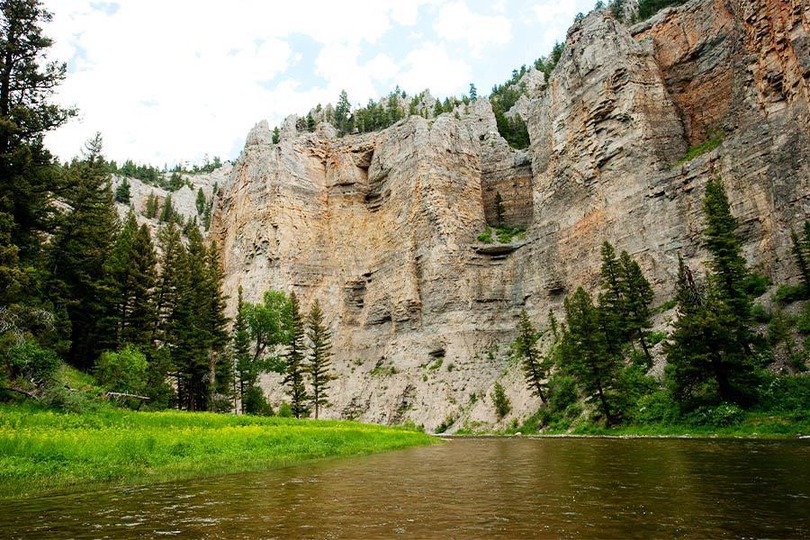 |
| FWP photo of the Smith River Canyon |
The Smith River and its 59-mile float trip (Camp Baker to Eden Bridge) in the limestone canyon between the Little and Big Belt mountains may be the crown jewel of the Little Belts experience.
Its scenery, fishing and wild experience has made it such a sought after trip that the Montana Department of Fish, Wildlife and Parks had to create a permit system to keep the river wild and prevent overuse.
Go to this Website for many details and FAQs on the trip:
https://fwp.mt.gov/stateparks/smith-river
Winter
O'Brien Creek ski trail (89) Cross Country/Moderate

The trail is straightforward --- start at King’s Hill Pass on the trail west of the pass clearly marked with blue diamonds. There’s about 500 feet of elevation gain, some of it up the Golden Goose run at Showdown, and then it is 2,000 feet l down hill to Neihart. It passes through a nicely recovered clearcut, across Divide Road, which is heavily hammered by snowmobile use, down into O’Brien Creek through a series of beaver willows frequented by moose, and past the O’Brien Creek water treatment plant and summer cabin areas before depositing you back on U.S. 89 at the Montana Department of Transportation maintenance sheds.


Shorty Creek-O'Brien Creek Loop Cross Country/Strenuous
 |
| Cutting a path up Shorty Creek |
SUMMARY: This is for well-conditioned skiers who are comfortable with off trail exploration.
From trip Dec. 19, 2005For
most backcountry skiers the 7-mile O’Brien Creek run from Kings Hills
in the Little Belt Mountains near Neihart is the ultimate experience.It starts high and ends low, offering a downhill ride and gorgeous creek bottom scenery.You
know the trip is over when you hit the Neihart water treatment facility
about three-quarters of a mile from U.S. 89 and the parking area at the
Montana Department of Transportation storage shed.In most years you hit a dip in the trail just before you come to the water plant.Until
recently I hadn’t given that much thought until Neihart Postmaster
Jasmine Krotkov showed me that that little “dip” is the key to a great
backcountry ski that rivals O’Brien Creek for beauty. That “dip” is
Shorty Creek.The
drainage originates below Divide Road, some 3 miles and 1,500 feet
above the water plant and features narrow canyons, open vistas and
spectacular outcroppings of volcanic rock.There is no trail, so it’s a matter of picking the best route up the bottom and through the trees.It is a steady, but not unreasonable uphill pull from the bottom.You’ll find the best entry point for this ski on the north side of Shorty Creek up a small hill and through some deep forest.It
passes through a tight canyon for about 1-1/2 miles before opening up
into a broad valley that offers views of surrounding open hillsides.After
enjoying the open, the last part of the ski plunges into deep forest,
where you’re forced to weave back and forth over snow bridges looking
for openings along the creek. The general rule is to stay to the north
side of the creek (your right) going up at first and as the trees become
more dense, look for a bench on the south side of the creek.There will be plenty of tree tangle in the last mile, which ultimately ends up on the Divide Road bench.We’ve
also done this ski downhill from Divide Road, reaching it from Johnston
Creek right out of Neihart. This is a very steep way to reach the road
and is hammered by snowmobiles.It
is quite the opposite of Shorty Creek, which unlike O’Brien Creek has
no road, no powerlines, and this year, anyway, no snowmobile traffic and
plenty of good snow.Eric Newhouse and I broke trail up Shorty Creek last Friday on a cold and overcast winter day.We went to about a half-mile below Divide Road and turned around an enjoyed a fast ride down and out.With
an additional 14 inches of snow on 4 feet of settled base, backcountry
skiing in the Little Belt Mountains near Neihart was ideal last week.Let’s hope this warm streak settles things up a bit before dumping more snow.
Ranch Creek (with Nugget Creek and Jumping Creek options) (89) Cross Country/Strenuous

SUMMARY:
This trip starts at Kings Hill Pass, climbs the Showdown ski hill to
Porphyry Peak and stays on the ridgeline past Mizpah bowls and drops
through a clearcut at the head of Ranch Creek before dropping to a
Forest Service Road and out. There are several variations on this ski
trip possible.
Of
the three designated backcountry trails that begin at King's Hill Pass,
the 9.6 miles Ranch Creek ski trip has evolved the most.It
started as a run that begins at on the west side of King's Hill Pass,
ascends Porphyry Peak (elevation: 8,210 feet), proceeds down the
Porphyry-Mizpah ridge to a large clearcut and then out on a Forest
Service Road paralleling Ranch Creek to US 89. It is still the standard
route.However
there have been variations that ended up at the former Forest Green
Resort (until access was restricted) and now an off-trail route that is
infrequently used down Nugget Creek to US 89.All
along the way on both routes there are good telemark possibilities for
those inclined, particularly in the Mizpah Peak bowls and the meadows
below it. Beware of avalanche. The area is prone to slides.The Nugget Creek option
is exciting because there is no trail when it leaves the Ranch Creek
route at about mile 6 where a ridge comes in from the southeast. It
climbs steeply, follows a ridge and the descends steeply, eventually
dropping through an old clearcut and out onto US 89 at Mile Marker 23
highway pullout. I suggest it be done only with someone who knows this
route. It is unmarked.One other option is the Jumping Creek run
that follows Forest Service Trail 747 all the way down the Mizpah Ridge
to Highway 89, rather than cutting down to Ranch Creek. There are
rocky sections along this route, so be careful.


SUMMARY: This trip starts at Kings Hill Pass, climbs the Showdown ski hill to Porphyry Peak and stays on the ridgeline past Mizpah bowls and drops through a clearcut at the head of Ranch Creek before dropping to a Forest Service Road and out. There are several variations on this ski trip possible.


Deadman Creek (89) Cross Country/Strenuous

SUMMARY:From King's Hill pass this trip climbs to the well-marked Deadman Ridge, across the ridge, past telemark bowls and down and out the Deadman Road.


727 loop (US 89) Cross Country/Moderate


SUMMARY:
A loop ski from Kings Hill Pass to the top of Porphyry Peak and about a
half mile beyond joins the 1-mile Trail 747 that connects to a
snowmobile trail. It travels to the O'Brien Creek run that can be skied
back out to Kings Hill Pass.
This is yet another of the loop trips that begins and ends at Kings Hill Pass.It is picked up on the west side of the pass at the O'Brien Creek cross country ski trail head.Then
it's up the trail until it meets the Showdown Ski Area Golden Goose
run, and then up the Forest Service Road to the Porphyry Peak Lookout
Tower, or the warming shelter at the ski area's top, and down the Mizpah
Ridge on FS Trail 727 following the Ranch Creek trail's blue diamonds.
In about a half-mile that parallels the downhill ski area, a trail sign
for FS Trail 747 appears. It is a 1-mile cutoff trail to FS Road 6413
that travels along the west/northwest side of Porphyry Peak. This
travels downhill roughly two miles where it meets the O'Brien Creek
trail (it is well marked), then it's a sharp right turn onto it and then
the ski hill and back to the car. Several words of caution about this
trip: FS Road 6413 can be groomed for snowmobiles, so watch out for
them, and a groomed trail can be icy and fast. Hang on to your hat if
it is. The FS Trail 727 is not well marked, and if the trail isn't
broken it can be difficult to follow. Look for cut logs, natural
openings, the upside-down exclamation point trail markers carved into
the trees, and cut branches that indicate a trail.


Nugget Creek Option

Matt Marcinek enroute

So,
here's the report on northcentral Montana's backcountry snow: lots of
new powder on top a crust that encases at least a foot of sugar snow
that never set up.
As we skied Nugget Creek in the Little Belts Wednesday we could punch our poles through the various layers to the ground.
The snow on the bottom, deposited in December, just never set up because of the bitter-cold weather.
That
was followed by more snow that was encased in the ice from a hard
Chinook melt and some rain. Then this week's powder ---- more than a
foot over three days ---- Sunday to Wednesday and more coming.
This is the oddest ski season I've encountered.

On Mizpah Ridge below Mizpah Peak (Gordon Whirry photo)
When
we could stay on the top of the crust it was great kick and glide
skiing. But, the crust would occasionally collapse and send us to the
ground. Yes, there was some "whoomphing" that cautioned us not to get
on any steep slopes. If we got going too fast telemarking a slope we'd
often run into a wall of that collapsed snow that had the effect of
running into large vat of mashed potatoes.
Nugget
Creek is the Wayne Phillips' created alternative to the Porphyry/Ranch
Creek run. We call it simply "High Porphyry" or "Nugget Creek."
Once
Ranch Creek headwall is reached, instead of dropping to the road,
Nugget Creek ascends a 300 foot ridge and then drops south and east
ultimately to Highway 89 at Mile Marker 123.
It
covers 10.3 miles, rises 1,700 feet and drops nearly 2,900 feet. It
starts at Kings Hill Pass, goes up Showdown Ski area to the top of
Porphyry Peak, across the ridge to Mizpah and then on to the Ranch Creek
headwall.
Yes, we got some turns in and enjoyed a gorgeous, if cold and snowy winter day, but the snow was weird.


SUMMARY: A loop ski from Kings Hill Pass to the top of Porphyry Peak and about a half mile beyond joins the 1-mile Trail 747 that connects to a snowmobile trail. It travels to the O'Brien Creek run that can be skied back out to Kings Hill Pass.


Nugget Creek Option
 |
| Matt Marcinek enroute |

As we skied Nugget Creek in the Little Belts Wednesday we could punch our poles through the various layers to the ground.
The snow on the bottom, deposited in December, just never set up because of the bitter-cold weather.
That was followed by more snow that was encased in the ice from a hard Chinook melt and some rain. Then this week's powder ---- more than a foot over three days ---- Sunday to Wednesday and more coming.
This is the oddest ski season I've encountered.
 |
| On Mizpah Ridge below Mizpah Peak (Gordon Whirry photo) |
Nugget Creek is the Wayne Phillips' created alternative to the Porphyry/Ranch Creek run. We call it simply "High Porphyry" or "Nugget Creek."
Once Ranch Creek headwall is reached, instead of dropping to the road, Nugget Creek ascends a 300 foot ridge and then drops south and east ultimately to Highway 89 at Mile Marker 123.
It covers 10.3 miles, rises 1,700 feet and drops nearly 2,900 feet. It starts at Kings Hill Pass, goes up Showdown Ski area to the top of Porphyry Peak, across the ridge to Mizpah and then on to the Ranch Creek headwall.
Yes, we got some turns in and enjoyed a gorgeous, if cold and snowy winter day, but the snow was weird.
Grendah Mountain (Weatherwax) (89) Cross Country/Off Trail Moderate
 |
| Reaching Grendah means following a lovely ridgeline most of the way |
 |
| The wind was nature's snow sculptor |
 |
| Near the top |
Some 2,000 feet are gained and lost along the way of this 9 mile roundtrip.
Start at the pass, ski behind the Forest Service cabin looking for a Road 487 that serves as a cross country ski/snowmobile trail to the top of Kings Hill. About a quarter mile up the road a lightly used snowmobile trail intersects. Take this to the top and climb Kings Hill Peak (elevation: 8,008 feet) a few feet to the south of the ridge. Ski north along the snomobile road to where it intersects with Road 8308. This road can be used all the way to the top of the peak. It stays on a ridge just north of the vast Weatherwax Creek bowls, and along the way great telemark ski terrain presents itself, mainly to the south.
There are great views of Yogo, Big Baldy, Coyote, Neihart and Long peaks in the distance. To the west, Showdown Ski Area and Porphyry Peak. There is a potential to bump into snowmobiles at any time, but eventually the trail narrows to a ridge line and it is yours on skis.
 |
| The geodesic marker at the mountain's top |
Jefferson Creek (89) Cross Country/Moderate
 |
| Katie in deep powder along Jefferson Creek |
I headed up into the Little Belts to look over the head of Jefferson Creek for winter use and to climb Tepee Butte (elevation: 8,240 feet) while I was there.
We picked up the Jefferson Creek Road off the Belt Creek Scenic Byway, a couple of miles south of the mining camp of Neihart. The road is rough, but passable. There are lots of pleasant, undesignated campgrounds along the 4 mile drive to the upper Jefferson Creek trailhead No. 740.
While we were expecting a thin Forest Service trail up to Tepee Butte, unfortunately we found a rather wide ATV track. Parts of the upper trail have been rebuilt to widen switchbacks.
 |
| Katie below Teepee Butte |
The trail gains more than 1,000 feet to the Dry Wolf Creek Road No. 251 over 2-1/2 miles. Then it is another 500 feet or so to the top of Tepee Butte, a small mountain that looks directly at some of the highest mountains in the Little Belts. There’s Yogo Peak (elevation: 8,801 feet) to the east, and the highest peak, Big Baldy (elevation: 9, 177 feet) to the north.
There are also splendid views of the Big Belt, Bridger, Crazy and Gallatin ranges far to the south.
There are gorgeous parks at the top of Jefferson Creek covered this year with wildflowers, a bonus from our extra-wet spring.
Chamberlin Creek/Jefferson Creek point to point (89) Cross Country/Strenuous
 |
| Yogo Peak in Little Belts on Upper Jefferson run (Gordon Whirry photo) |


XXX Bender Creek Trail 731 (89/Dry Fork) Moderate. Cross Country Ski
 |
| Tracking deep powder in Bender Creek meadow |
Here the trail takes a 90 degree turn up and into the trees, a trail that can be difficult to find. It then takes broad switchbacks through open tele slopes and lodgepole pines, eventually cresting Hoover Ridge, having climbed nearly 1,500 feet and traveling 2.6 miles from the start.
On the way back down we took advantage of some low angle tele slopes for a few turns before plunging back into the creek bottom, where a command of telemark turns is a must. I wore a helmet and was glad I did.
The scenery in the Bender is particularly good in the open tele slopes looking north toward towering and snow-capped Mount Barker, just under 9,000 feet.
XXX (Hoover-Henn option) (89/Dry Fork) Trails 731/736 Difficult. Cross Country Ski
 |
| A view from the Hoover Ridge top looking east toward Old Baldy |
SUMMARY: DIFFICULT. A gorgeous winter backcountry ski or snowshoe trip that presents some trail finding challenges.
From trip on Feb. 6, 2014:This
9-mile traverse travels up the Bender Creek valley to the Hoover Ridge
top and over to Henn Creek, gaining and losing nearly 2,500 feet in the
Little Belt Mountains south and east of Great Falls.
The
ridge itself is heavily timbered and gentle to follow along a newly
reconstructed and reconfigured Trail 736. Our route was a blend of the
old and new trails.
Along
the way there are extraordinary open parks that make for good telemark
turns on a backcountry ski trip and vistas of such mountains as Servoss
and Barker to the west and north and the Big Baldy (over 9,000 feet) to
the east.
While there are old roads and mining claims, this area maintains a wild character in the winter.
Our
trip was icy cold to begin with; the temperature 7 below zero, which
never rose above 18 degrees despite bright blue skies and radiant
sunlight.
As
we topped the final ridgeline we temporarily lost and regained the old
trail and then lost it again and found ourselves steeply descending to
the Henn/Ruby divide, finally coming out at the new Trail 736 trailhead.
Unfortunately, we didn't have the advantage of open tele slopes, but
had to bushwhack around deadfall and brush and closely spaced trees.
Then it was two miles down a fast and sometimes the steep Henn Gulch road used by snowmobilers and skiers in the winter.
This
area is accessed from Monarch by the Dry Fork/Hughesville Road, with
Bender Creek about 9 miles from the turnoff, and good starting point.
On that road it is about a mile between Bender and Henn Gulch access
points.
This
was one in a series of Wayne's Wednesday Wild Walks, and conceived by
Chuck Jennings, who has hiked sections of it in the summer.
The ridge itself is heavily timbered and gentle to follow along a newly reconstructed and reconfigured Trail 736. Our route was a blend of the old and new trails.
Along the way there are extraordinary open parks that make for good telemark turns on a backcountry ski trip and vistas of such mountains as Servoss and Barker to the west and north and the Big Baldy (over 9,000 feet) to the east.
While there are old roads and mining claims, this area maintains a wild character in the winter.
Our trip was icy cold to begin with; the temperature 7 below zero, which never rose above 18 degrees despite bright blue skies and radiant sunlight.
As we topped the final ridgeline we temporarily lost and regained the old trail and then lost it again and found ourselves steeply descending to the Henn/Ruby divide, finally coming out at the new Trail 736 trailhead. Unfortunately, we didn't have the advantage of open tele slopes, but had to bushwhack around deadfall and brush and closely spaced trees.
Then it was two miles down a fast and sometimes the steep Henn Gulch road used by snowmobilers and skiers in the winter.
This area is accessed from Monarch by the Dry Fork/Hughesville Road, with Bender Creek about 9 miles from the turnoff, and good starting point. On that road it is about a mile between Bender and Henn Gulch access points.
This was one in a series of Wayne's Wednesday Wild Walks, and conceived by Chuck Jennings, who has hiked sections of it in the summer.
Comments
Post a Comment